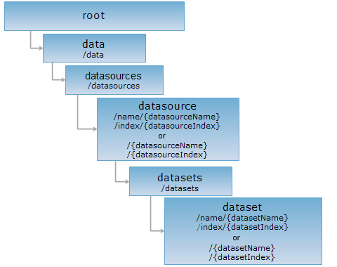
features, fields, domain, gridValues, gridValue, imageValues, imageValue
The dataset resource represents a dataset. By implementing the GET request on the dataset resource, you can get the descriptive information about the dataset ({datasetName} or {datasetIndex}). The PUT and DELETE requests are used to modify and delete a dataset. When the dataset resource specified does not exist on the server, the PUT request creates a dataset on the server.
Note: 1. The dataset resource supports the above 4 ways of URIs, URI1 and URI3 uses dataset name to identify resources, URI2 and URI4 uses dataset index identify resource; 2. When <datasource_uri> in <datasets_uri> uses URI1 or URI2, dataset can only use URI2 or URI2, When <datasource_uri> in <datasets_uri> uses URI3 or URI4, dataset can only use URI3 or URI4.
Supported Methods:
Supported output formats: rjson, json, html, xml.

Execute HTTP request on the following URI, using the rjson output format as an example, where supermapiserver is the server name, World is a datasource on the server, and Countries is a vector dataset in the datasource.
http://supermapiserver:8090/iserver/services/data-world/rest/data/datasources/name/World/datasets/name/Countries.rjson
Gets the information about the dataset.
None.
When executing the GET request on the dataset resource, the representation of the resource returned is included in the entity body of the response message, as shown below:
| Field | Type | Description |
| datasetInfo | DatasetInfo | The information about the dataset. |
| childUriList | List<String> | The child resource list. |
The structure of DatasetInfo is as follows:
| Field | Type | Description |
| name | String | The dataset name, used to uniquely identify a dataset. The dataset name is not case-sensitive. |
| description | String | The description information of the dataset. |
| type | DatasetType |
The dataset type. |
| bounds | Rectangle2D | The dataset bounds. For a vector dataset, the bounds of the dataset is the minimum bounding box of all features in the dataset. For a raster dataset, the bounds of the dataset is the geographical extent of the grid or image dataset. |
| dataSourceName | String | The name of the datasource in which the dataset resides. |
| encodeType | EncodeType | The encoding modes for dataset compression |
| isReadOnly | boolean | Whether the dataset is readonly. |
| prjCoordSys | PrjCoordSys | the projection information of the dataset. |
| tableName | String | The name of the table. For database datasources, it represents the data table name corresponding to this dataset in the database; for file datasources, it represents the table name of this dataset used to store the attributes (files of file datasources store spatial data by .udb files and store attribute data by .udd files). |
| charset | Charset | The charset of the vector dataset. For vector dataset only. |
| isFileCache | boolean | Whether to enable file caches. For vector dataset only. |
| recordCount | int | The number of records of the vector dataset. For vector dataset only. |
| blockSize | int | The size of a block while storing in pixel blocks. For image or grid dataset only. |
| height | int | The height of the data. For image or grid dataset only. |
| width | int | The width of the data. For image or grid dataset only. |
| pixelFormat | PixelFormat | The pixel format for data storage. For image or grid dataset only. |
| isMultiBand | boolean | Whether the image dataset has multiple bands. For image dataset only. |
| palette | List<java.awt.Color> | The color palette of the image data. For image dataset only. |
Execute the GET request on the sample dataset resource with http://supermapiserver:8090/iserver/services/data-world/rest/data/datasources/name/World/datasets/name/Countries.rjson and get the representation of the Countries dataset (vector dataset) in rjson format.
{
"childUriList": [
"http://supermapiserver:8090/iserver/services/data-world/rest/data/datasources/name/World/datasets/name/Countries/fields",
"http://supermapiserver:8090/iserver/services/data-world/rest/data/datasources/name/World/datasets/name/Countries/features"
],
"datasetInfo": {
"bounds": {
"bottom": -90,
"left": -180,
"leftBottom": {
"x": -180,
"y": -90
},
"right": 180,
"rightTop": {
"x": 180,
"y": 83.62359619140626
},
"top": 83.62359619140626
},
"charset": "GB18030",
"dataSourceName": "World",
"description": "",
"encodeType": "NONE",
"isFileCache": false,
"isReadOnly": false,
"name": "Countries",
"prjCoordSys": {
"coordSystem": {
"datum": {
"name": "D_WGS_1984",
"spheroid": {
"axis": 6378137,
"flatten": 0.0033528107,
"name": "WGS_1984",
"type": "SPHEROID_WGS_1984"
},
"type": "DATUM_WGS_1984"
},
"name": "GCS_WGS_1984",
"primeMeridian": {
"longitudeValue": 0,
"name": "Greenwich",
"type": "PRIMEMERIDIAN_GREENWICH"
},
"spatialRefType": "SPATIALREF_EARTH_LONGITUDE_LATITUDE",
"type": "GCS_WGS_1984",
"unit": "DEGREE"
},
"coordUnit": "DEGREE",
"distanceUnit": "METER",
"epsgCode": 1,
"name": "Longitude / Latitude Coordinate System---GCS_WGS_1984",
"projection": null,
"projectionParam": null,
"type": "PCS_EARTH_LONGITUDE_LATITUDE"
},
"recordCount": 247,
"tableName": "Countries",
"type": "REGION"
}
}
Execute the GET request on the sample dataset resource with http://localhost:8090/iserver/services/data-world/rest/data/datasources/name/World/datasets/name/Capitals.kml to get the response in kml format (the kml representation of point, line, and region datasets supported only), as shown below:
<?xml version="1.0" encoding="utf-8" standalone="no" ?>
<kml>
<Document>
<NetworkLink>
<Link>
<href>http://localhost:8090/iserver/services/data-world/rest/data/datasources/name/World/datasets/name/Capitals/features.kml</href>
</Link>
</NetworkLink>
</Document>
</kml>
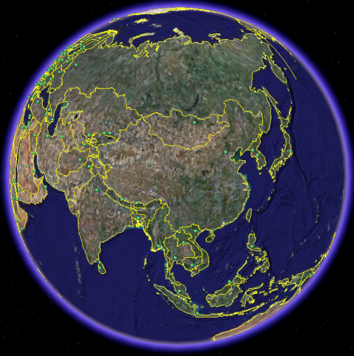
Access http://localhost:8090/iserver/services/data-world/rest/data/datasources/name/World/datasets/name/Capitals.kml in GoogleEarth to get the response as shown below:

Above is the default display effect. Please refer to %SuperMap iServer Java_HOME%\WEB-INF\lib\iserver-all-{version}.jar\config\kml\styles\default.xml for default xml display style.
Users can customize their own display styles for the kml representation of the dataset. Please see Managing Services>Configuring KML Styles.
Creates or modifies the information about the dataset (only vector dataset supported currently). create when the specified datasource doesn't exist; otherwise, modify.
If the dataset resource doesn't exist, a dataset will be created when executing the PUT request on a new URI. Parameters need to be included in the request body are as follows:
| Name | Type | Description |
| datasetName | String | The dataset name. Please make sure that is is consistent with {datasetName} in the URI. |
| datasetType | DatasetType | The dataset type. The dataset type. The supported types includes: point, line, region, text, CAD and tabular dataset. |
| isFileCache | boolean | Whether to enable file caches. For vector dataset only. |
If the dataset resource exists, the dataset information will be modified by executing the PUT request on the dataset resource. Parameters need to be included in the request body are as follows:
| Name | Type | Description |
| description | String | The description information of the dataset. |
| prjCoordSys | PrjCoordSys | the projected coordinate system. |
| charset | enum | the vector dataset charset. [Optional]Transferred if the dataset is a vector dataset. The encoding mode will remain unchanged if null value is transferred. |
| palette | java.util.List<Color> | the color palette of the image dataset. [Optional]Transferred if the dataset is an image dataset. |
| noValue | double | The value of pixles with noData. [Optional]Transferred if the dataset is an grid dataset. |
The returned resource representation structure is as follows if executing PUT request on the dataset resource (resource representation is in the entity body of the response message):
| Field | Type | Description |
| succeed | boolean | Whether the operation is successful. |
| newResourceLoaction | String | The URI of the newly created dataset. Not exist if the PUT request implements the modify operation. |
| error | HttpError | Error message. If the creation is successful, this field will be absent. |
When you execute the PUT request on the dataset resource that doesn't exist, the PUT request creates a dataset. For example, if you execute the PUT request on http://supermapiserver:8090/iserver/services/data-world/rest/data/datasources/name/World/datasets/name/World1.rjson, however, there is no World1 in World, a new dataset named World1 will be created in the World datasource.
The request body for executing the PUT request on http://supermapiserver:8090/iserver/services/data-world/rest/data/datasources/name/World/datasets/name/World1.rjson is as follows:
{"datasetType":"POINT","datasetName":"World1"}
The response in json format is as follows:
{
"newResourceLocation": "http://supermapiserver:8090/iserver/services/data-world/rest/data/datasources/name/World/datasets/name/World1",
"succeed": true
}
If you execute the PUT request on http://supermapiserver:8090/iserver/services/data-world/rest/data/datasources/name/World/datasets/name/World1.rjson, and there is World1 in World, World1 will be modified. Parameters transferred in the request body when executing the PUT request on the URI are as follows:
{
"isFileCache": "true",
"description": "123",
"prjCoordSys": {
"coordUnit": "MILE",
"name": "Tokyo UTM 51",
"epsgCode": 3902,
"projection": null,
"coordSystem": null,
"type": "PCS_USER_DEFINED",
"distanceUnit": null,
"projectionParam": null
},
"charset": "GB18030"
}
The response in json format is as follows:
{"succeed": true}
Delete the dataset. As to the sample dataset resource, or the URI, the DELETE request deletes the Countries dataset in the World datasource.
None.
When executing the DELETE request on the dataset resource to delete a dataset, the response is as follows:
| Field | Type | Description |
| succeed | boolean | Whether the delete operation is successful. |
| error | HttpError | Error message. If successful, the field will not exist. |
Execute the Delete request on the sample dataset resource with http://supermapiserver:8090/iserver/services/data-world/rest/data/datasources/name/World/datasets/name/Countries.rjson to delete the Countries dataset and get the response in rjson format.
{"succeed": true}
Asks for the response identical to the one that would correspond to a GET request, but without the response body. This is useful for retrieving meta-information written in response headers, without having to transport the entire content. The meta-information includes the media-type, content-encoding, transfer-encoding, content-length, etc.
The HEAD request helps check the existence of the dataset resource and whether it can be accessed by the client. By sending the HEAD request on the URI, with .<format> appended to the end, we can quickly get to know whether the dataset resource supports the representation in <format> or not.