
Rule modeling |
When you add or create new data that is point data, click dataset actions to bring up a panel that includes: property table, position, add symbol, rename, refresh or edit, and delete.
Click add symbol and the add symbol panel will pop up on the right side of the screen.
|
Select SMID: you can directly fill in the ID number, for example, "1,2" represents the objects with ID 1 and 2 to participate in adding symbols, or you can use conditional expression to select the objects that satisfy the conditional statement to participate in adding symbols. |
| Symbol type: the target style of point symbolization, supporting three types: trees, utilities and traffic. | |
| Rotation: in degrees, the magnitude of the angle at which the symbolic model is rotated around the x, y, and z axes, respectively. | |
| Zoom: The proportional size of the symbol to zoom in or out in the x, y, and z directions, respectively. | |
| Color: The appearance color of the symbol. You can click the color value to the right of the material color and set the color by entering an RGBA value in the pop-up color panel, or you can pick up the color by clicking the color map. |
When the data you add is facet data, click on the dataset operation and the pop-up panel includes: property table, position, stretch, rename, and delete.
Click "Stretch" and the stretching panel will pop up on the right side of the screen.
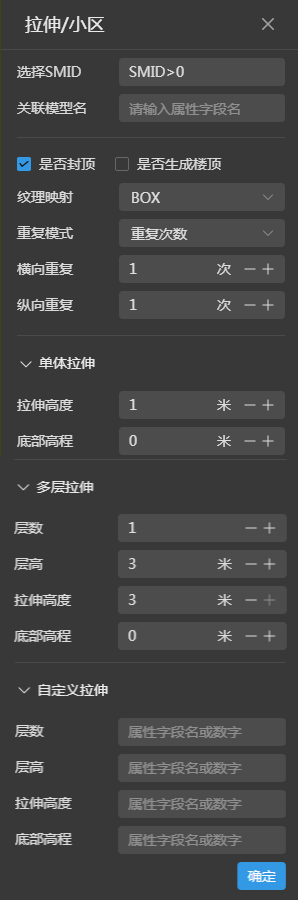 |
Select SMID: you can directly fill in the ID numbers, such as "1,2" represents the ID of 1 and 2 objects to participate in the stretch operation, you can also use conditional expressions to select the objects that meet the conditions of the statement to participate in the stretch operation. |
| Associated model name: assign a uniform name to the objects involved in the stretch operation. If you set the model name + "_" the system will sort after the underscore. | |
| Capped or not: uncapped means that the constructed model is a box without a top surface. | |
| Generate roof or not: indicates whether the constructed building model has a roof. | |
|
Texture mapping: Support BOX, PLANAR, SPHERICAL, refer to texture mapping content in note for details. |
|
|
Repeat mode: Support both repeat count and true size modes. |
|
| Repeat in the horizontal and vertical directions: the unit is meter when the true size is selected, and the unit is times when the number of repetitions is selected. | |
| Monolithic stretching: faces are stretched into non layered buildings based on numbers. | |
|
Stretch height: the total height of the building. You can enter a number or click "+" or "-" to control the stretch height. |
|
|
Bottom elevation: the bottom elevation of the building. you can enter numbers or click "+" or "-" to control the bottom elevation. |
|
|
Multi-layered stretching: the surface is stretched according to the number of layers of the building. |
|
|
Number of floors: the natural number of floors of the building, you can enter a number or click "+" or "-" to control the number of floors. |
|
| Floor height: the height of each floor of the building, you can enter a number or click "+" or "-" to control the floor height. | |
| Stretch height: the height of each layer of the vector surface stretching, this parameter can not be greater than the layer height, when equal to the layer height, is the layer of the building connected to the layer. you can enter a number or click "+" or "-" to control the stretch height. | |
|
Bottom elevation: the bottom elevation of the building, you can enter the number or click "+" or "-" to control the bottom elevation. |
|
|
Custom stretch: facets stretch the building of a component layer based on attribute fields or data. |
|
|
Number of storeys: The natural number of storeys in the building. you can enter the attribute field name to set the number of storeys. |
|
|
Floor height: the height of each floor of the building. you can set the floor height by entering the name of the attribute field. |
|
| Stretch height: the height of each layer of the vector surface stretched, this parameter can not be greater than the layer height, when equal to the layer height, it is the building where the layer is connected to the layer. you can enter the attribute field name to control the stretch height. | |
| Bottom elevation: the bottom elevation of the building, you can enter the attribute field name number to control the bottom elevation. |
Note:
1. Please refer to texture mapping stream for a detailed explanation of the texture mapping method.
2. When you forget an attribute field name when using custom stretching, you can click the dataset action, select the attribute table, and view the attribute field name.
3. The three types of stretches single stretch, multi-stretch, and custom stretch are mutually exclusive. When you select single stretch, the other two parameter panels are automatically tucked away.
4. When the floor height is the same as the stretched height, the building is constructed with floors connected to each other, and when the floor height is larger than the stretched height, the floor slab of each floor can be constructed. When the floor height is larger than the stretch height and not capped, the balcony of each floor can be built.
5. If the surface data is a 3D surface, the bottom elevation can be set to 0. The bottom elevation of the model is the center point elevation of the 3D surface.
6. Repeat mode: When the actual size is selected the pixels of the mapping represent the actual size, for example 100 pixels represent 1 meter.
 |
Select SMID: you can directly fill in the ID numbers, such as "1,2" representing the ID of 1 and 2 objects to participate in the stretch operation, you can also use conditional expressions to select the objects that meet the conditions of the statement to participate in the release operation. |
| Model name: assign a uniform name to the objects involved in the stretch operation. If you set the model name + "_" the system will sort after the underscore. | |
|
Start and end face: including without start and end face, with start and end face, with end face, with start and end face. |
|
|
Smoothing degree: fit a curve to the line data, the larger the value, the smoother the line segment. Click to view the line smoothing details. |
|
|
Texture mapping: Support BOX, PLANAR, SPHERICAL. |
|
|
Repeat mode: support both repeat count and true size modes. |
|
|
Horizontal and vertical dimensions: the unit is meter when the true size is selected, and the unit is times when the number of repetitions is selected. |
|
| Offset centerline: the first parameter is the X offset and the second parameter is the Y offset. that is, the line data is panned on the XY plane and does not change the height value of the line. | |
|
Road release: build road model based on parameters. |
|
|
Upper width: the width of the top of the road, you can enter a number or click "+" or "-" to control the upper width. |
|
|
Lower Width: the width of the bottom of the road, you can enter a number or click "+" or "-" to control the lower width. |
|
|
Road thickness: the vertical distance from the top to the bottom, you can enter a number or click "+" or "-" to control the road thickness. |
|
|
Pipeline latout: construct both round and square pipelines according to the parameters. |
|
|
Pipe type: circular pipe radius: in meters, can be controlled by entering numbers or clicking "+" or "-"; |
|
|
Pipe type: square pipe width: in meters, can be controlled by entering numbers or clicking "+" or "-";Height: the total height from the top to the bottom of the square tube; |
|
|
Roadway layout: build roadway model according to parameters, click to view roadway details. |
|
|
Width: the width of the bottom of the aisle, which can be controlled by entering a number or clicking "+" or "-"; |
|
|
Height: the height of the aisle, which can be controlled by entering a number or clicking "+" or "-"; |
|
|
Arch height: the vertical height of the arch geometry of the roadway, which can be controlled by entering a number or clicking "+" or "-"; |
|
| Gutter layout: construct "concave" gutter model by parameters. | |
|
Top width: the width of the top of the model, which can be controlled by entering a number or clicking "+" or "-"; |
|
|
Lower width: the width of the bottom of the model, which can be controlled by entering a number or clicking "+" or "-"; |
|
|
Height: the vertical distance from the top to the bottom of the model, which can be controlled by entering a number or clicking "+" or "-"; |
|
| Thickness: the thickness of the gutter wall, which can be controlled by entering a number or clicking "+" or "-"; | |
| Customized release: Constructs a released cross-section by entering coordinate points in a planar, non-projective cartesian coordinate system, and generates a model based on the constructed cross-section. | |
| Cross-section type: supports both line and surface data types. | |
| Line data: Line data cross-section coordinates are arranged in the format of [x1,y1,x2,y2, ... ,xn,yn], for example, if you enter [-2,1,2,1] in the text box as described in the example, the model will be generated based on the line data cross-section constructed from these two pairs of coordinate points. | |
|
Surface data: The surface data section can be constructed in two formats: one is to represent the boundary of the surface by a set of coordinate point strings, the coordinates are arranged in the format of [x1,y1,x2,y2,.... ,xn,yn], for example, if you enter [-2,1,2,1,2,3,-2,3] in the text box as described in the example, the model will be generated based on the cross-section of the face data constructed by these four pairs of coordinate points. Secondly, the external and internal boundaries of the surface data are represented by two sets of coordinate point strings, respectively, and the coordinates are arranged in the format of [x1,y1,x2,y2, ... ,xn,yn],[x1,y1,x2,y2,... ,xn,yn], where the external coordinates are arranged in counterclockwise order and the internal in clockwise order. For example, if you enter in the text box as described in the example[-2,1,2,1,2,3,-2,3], [-1,1,-1,2,1,2,1,2,1,1], a model will be generated based on the cross-section release of the surface data constructed from these 2 sets of coordinate points. |
Note:
1. The four types of releases, namely road release, pipe release, alley release and gutter release, are mutually exclusive. When you select road release, the other three parameter panels will be automatically closed.
2. Select SMID can not use SMID = 1 to operate on 1 object, you can set SMID == 1 or directly fill in 1, both can operate on 1 object.
3. Repeat mode: when the actual size is selected the pixels of the mapping represent the actual size, for example 100 pixels represent 1 meter.
You can perform different operations on different types of model sets generated by rule-based modeling. You can do model positioning, renaming, refreshing, and model deletion for point model sets, model positioning, renaming, refreshing, model deletion, and material editing for line model sets, and model positioning, renaming, refreshing, model deletion, material editing, and style setting for surface model sets.
Click modelset actions, and in the modelset actions list, click model locate to locate the camera to the specified model dataset.
You can modify the modelset name here. Click modelset actions, select rename in the modelset operation list and the modelset name becomes modifiable, enter the modified name and click "Enter" to end the modification.
Click modelset actions, and in the modelset actions list, click rename and you can refresh the model dataset.
Click modelset actions, and in the modelset actions list, click model delete, and you can delete the currently selected modelset.
You can operate on individual models under the modelset, which supports model positioning, model editing, renaming, and model deletion for point data models, model positioning, model editing, renaming, model deletion, and material editing for line data models, and model positioning, model editing, renaming, model deletion, material editing, and style setting for surface data models.
Click modelset actions, and in the modelset actions list, click model positioning to position the camera to the specified model.
Monolithic stretch
Multi-layer stretch
Custom Stretch
Road Release
Pipeline plotting
Roadway release
Gutter release
Custom release
Click modelset actions, and in the modelset actions list, click Rename, and you can enter a new name for the model.
Click modelset actions, and in the modelset actions list, click model delete, and you can delete the specified model object.